Our next weather maker is a cold front that will bring colder temperatures and a chance for thunderstorms early Thursday morning.
Today will be mostly sunny with highs around 61 and winds from the SW at 5-10 mph. Tonight's low will be 52.
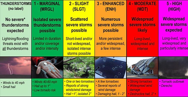
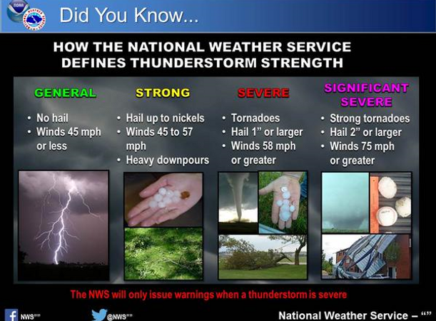
Increasing clouds on Wednesday with a high near 70. Winds will be from the SW at 10-15 mph. Our low Wednesday night will be in the middle 50's. A line of showers and thunderstorms will move through the metro area beginning around 3 am Thursday morning. Isolated storms could be strong. Chances for showers and storms will be around 60%.
Thursday will be cloudy with slowly falling temperatures throughout the day. We start out in the middle 50's and should be in the middle 40's by sunset. Winds will be from the SW in the morning, then from the NW in the afternoon at 15-20 mph with higher gusts. The low Thursday night will be in the middle 30's.
Mostly sunny Friday with highs in the middle 40's and lows in the upper 20's. Sunny on Saturday with highs in the middle 40's and lows in the middle 30's.
Mostly sunny Sunday with highs in the middle 50's and lows near 50. Monday will be mostly cloudy with highs in the lower 60's and a 30% chance for late afternoon showers.
Yesterday's high in Olive Branch was 58. Our overnight low has been 36. The record high for this date was 75 in 1890 and the record low was -2 in 1886.
Rainfall recorded by midnight was 0.00”. The total for the month is 3.20”. Year to date rainfall is 3.20 inches.
The average high/low is 50 and 33. Sunrise is at 7:08 am and sunset is at 5:06 pm which is 0 minutes and 59 seconds MORE daylight compared to yesterday.


My Channel
My Channel


Pulse Storm Lesson

Just the Weather, Without the Drama

Tornado Radar

Be Aware Outdoors